
Publisher:
Bonnie King
CONTACT:
Newsroom@Salem-news.com
Advertising:
Adsales@Salem-news.com

~Truth~
~Justice~
~Peace~
TJP
Aug-11-2009 00:19

 TweetFollow @OregonNews
Old McKenzie Pass Highway Now Open
Salem-News.comThe "old" McKenzie Pass Highway became a seasonal scenic highway in 1962.
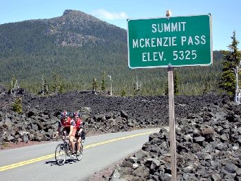 Cyclists cross and descend the McKenzie Pass on Oregon Route 242 July 07,2005 Wikimedia Commons image [David Hunter, Nashville, TN] |
(SPRINGFIELD, Ore.) - The McKenzie Pass Highway (OR 242) is now officially open to all traffic. The highway has been closed to complete a highway repaving project that has now been completed.
The nearly $4 million dollar project, funded by the Federal Highway Administration, cut back the slope and realigned the highway, replaced two bridges and repaved the highway surface making the road more stable and safe for all users.
Motorists driving on this curvy road need to be aware of bicyclists and pedestrians on the roadway and take proper precautions. Vehicles longer than 35 feet are prohibited from using the highway.
The first route over the McKenzie Pass, known as Craig's McKenzie Salt Springs/Deschutes Wagon Road, was completed in 1872. This toll road connected the Willamette Valley with Camp Polk, near what is now Sisters. The charge was $2 for a wagon drawn by two horses, $2.50 for a wagon with four horses, $1 for a man on a horse and 10 cents each for loose cattle and horses.
Modern construction techniques allowed crews to rebuild the road in the 1920s. At that time, the McKenzie Pass Highway was built and the former wagon route was abandoned, except in places where the new highway followed the same path.
In 1936 the Clear Lake-Belknap Springs section of OR 126 was completed, giving motorists a new, straighter, year-round alternative for travel between the Willamette Valley and Central Oregon.
The McKenzie Pass Highway became a seasonal scenic highway in 1962 with the completion of the Clear Lake-Belknap Springs section of OR 126.
Even during its tenure as the main route between the southern Willamette Valley and Central Oregon, the narrow, twisting roadway and high elevation (5,325 feet) made the highway too difficult to maintain and keep clear during the winter months.
Source: Oregon Department of Transportation
Articles for August 10, 2009 | Articles for August 11, 2009 | Articles for August 12, 2009

Salem-News.com:


Quick Links
DINING
Willamette UniversityGoudy Commons Cafe
Dine on the Queen
Willamette Queen Sternwheeler
MUST SEE SALEM
Oregon Capitol ToursCapitol History Gateway
Willamette River Ride
Willamette Queen Sternwheeler
Historic Home Tours:
Deepwood Museum
The Bush House
Gaiety Hollow Garden
AUCTIONS - APPRAISALS
Auction Masters & AppraisalsCONSTRUCTION SERVICES
Roofing and ContractingSheridan, Ore.
ONLINE SHOPPING
Special Occasion DressesAdvertise with Salem-News
Contact:AdSales@Salem-News.com
Terms of Service | Privacy Policy
All comments and messages are approved by people and self promotional links or unacceptable comments are denied.
[Return to Top]
©2026 Salem-News.com. All opinions expressed in this article are those of the author and do not necessarily reflect those of Salem-News.com.