
Publisher:
Bonnie King
CONTACT:
Newsroom@Salem-news.com
Advertising:
Adsales@Salem-news.com

~Truth~
~Justice~
~Peace~
TJP
Feb-24-2011 15:36

 TweetFollow @OregonNews
Winter's Worst Hitting the Northwest
Salem-News.comAnother storm will threaten the Northwest early next week.
 Images: AccuWeather.com |
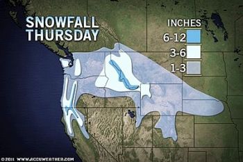
(STATE COLLEGE, Pa.) - AccuWeather reports from heavy, wet snow over the Olympic Peninsula to blizzard conditions and dangerous cold in the northern Rockies, winter's worst is hitting the Northwest today.
From 6 to 12 inches of wet snow has fallen on the Olympic Peninsula. Between 3 and 6 inches of snow has plastered areas from Seattle to Portland. Spokane has been slammed with a foot of wind-blown powder.
Up to several additional inches of snow will fall on these areas until the storm breaks out.
Fortunately, where most of the wet snow has fallen, winds have been generally light. Even so, without the wind, some tree limbs may come down under the weight of clinging heavy snow, perhaps taking power lines with them from western Washington to portions of western Oregon.
Travel will be slippery along portions of Interstate 5 from Washington southward into northern California with road conditions ranging from wet with slushy spots in low elevations to snow-covered in the hilly and inland areas.
Keep in mind as temperatures fall tonight in the wake of the storm throughout the coastal Northwest, any untreated wet and slush areas will turn to ice!

Long stretches of I-90 will be snow-covered and slippery, especially through the Cascades and from eastern Washington and on through the Bitterroots then into northern Montana. Winds generally increase as you head to the east.
The worst conditions will generally be over the passes where episodes of poor visibility accompany snow-packed roads. Traction tires or chains may be required through many of these areas.
A somewhat less intense route in terms of the snow is along I-84 east of the Gorge. However, there has been some snow around Pendleton and into the Blue Mountains of eastern Oregon. Little or no snow was expected to fall over the Snake River Valley of southern Idaho. Keep in mind, even a thin coating of snow can make roads quite slippery and lead to an accident.
Motorists traveling along I-5 from Seattle to Southern California will have the snow tag along with them much of the way. Typically, a storm like this would stay local, but not this one.
Weather Goes South This Weekend The snow will end from north to south over the Northwest later today into Friday, but cold will remain firmly in place into the weekend.
This storm will bring accumulating snow all the way down through I-80 in the Sierra Nevada and the Grapevine north of L.A. as well as along I-40 in the mountains of Arizona into the weekend as it settles over the Southland.
Only the lowest elevations in the San Joaquin Valley and Southern California will escape the snow. And, even in parts of these valley and basin areas, wet snow can mix in.
A new storm will threaten the Northwest early next week. While the early indications are that this storm will be a somewhat warmer feature for the coastal areas, it could still put down very heavy snow in the mountains and a wintry mix across the interior.
By Alex Sosnowski, Senior Expert Meteorologist for AccuWeather.com
Articles for February 23, 2011 | Articles for February 24, 2011 | Articles for February 25, 2011

Quick Links
DINING
Willamette UniversityGoudy Commons Cafe
Dine on the Queen
Willamette Queen Sternwheeler
MUST SEE SALEM
Oregon Capitol ToursCapitol History Gateway
Willamette River Ride
Willamette Queen Sternwheeler
Historic Home Tours:
Deepwood Museum
The Bush House
Gaiety Hollow Garden
AUCTIONS - APPRAISALS
Auction Masters & AppraisalsCONSTRUCTION SERVICES
Roofing and ContractingSheridan, Ore.
ONLINE SHOPPING
Special Occasion DressesAdvertise with Salem-News
Contact:AdSales@Salem-News.com


Terms of Service | Privacy Policy
All comments and messages are approved by people and self promotional links or unacceptable comments are denied.
[Return to Top]
©2026 Salem-News.com. All opinions expressed in this article are those of the author and do not necessarily reflect those of Salem-News.com.