
Publisher:
Bonnie King
CONTACT:
Newsroom@Salem-news.com
Advertising:
Adsales@Salem-news.com

~Truth~
~Justice~
~Peace~
TJP
Jan-02-2008 13:18

 TweetFollow @OregonNews
Parade of Pacific Storms Will Spread Rain and Snow from Canada to Mexico (VIDEO)
Salem-News.comIntense winds will add to the severity of the storms in the Sierra, with blizzard conditions creating extremely dangerous travel conditions in the mountains.
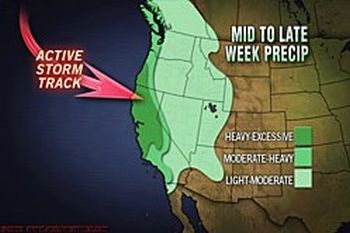 Image and video courtesy of Accuweather.com |
(STATE COLLEGE, Pa.) - The nation's western states will undergo a change in the weather in the upcoming days. The widespread dry weather that dominated the region as 2008 arrived will be replaced by the return of the parade of Pacific storms.
The storms will spread rain and snow from British Columbia to the Mexican border, with the heaviest snow and rain targeting northern and central California.
Between Thursday and Sunday, a trio of storms will slam into the West Coast. The storms will tap into the abundant moisture from the Pacific, producing several feet of new snow in the Sierra and potentially flooding rain at lower elevations.
Snow amounts from the upcoming storms could rank among the top 15 snowstorm totals in the Sierra over the past 50 years. Topping the list is the storms in mid-January 1952, when Tahoe City, Calif., was buried under more than 12 feet of snow.
The worst of the stormy weather will be from the storm reaching northern and central California on Friday, with drenching rain and a threat of flash flooding reaching Southern California by Saturday.
Intense winds will add to the severity of the storms in the Sierra, with blizzard conditions creating extremely dangerous travel conditions in the mountains. In fact, very windy conditions are possible the National Weather Service says, along The South Washington And North And Central Oregon Coasts Thursday And Friday And Friday night.
On Saturday morning, a series of rather strong low pressure systems and Pacific frontal systems are showing forecasters the potential to being a couple of periods of fairly strong and gusty winds to the coast, especially near the headlands and beaches.
Weather model details have been varying winds near the coastal headlands could gust up to 55 mph both on Thursday and again on Friday.
Meteorologists caution that there is some risk that gusts both days could exceed 60 mph with the strongest low pressure area offshore and best potential for high winds along the coast Friday night and into Saturday morning.
Special thanks to Accuweather.com for information in this weather report.
--------------------------------------------------------
Here is a video report on Northwest weather:
Articles for January 1, 2008 | Articles for January 2, 2008 | Articles for January 3, 2008
Salem-News.com:

Quick Links
DINING
Willamette UniversityGoudy Commons Cafe
Dine on the Queen
Willamette Queen Sternwheeler
MUST SEE SALEM
Oregon Capitol ToursCapitol History Gateway
Willamette River Ride
Willamette Queen Sternwheeler
Historic Home Tours:
Deepwood Museum
The Bush House
Gaiety Hollow Garden
AUCTIONS - APPRAISALS
Auction Masters & AppraisalsCONSTRUCTION SERVICES
Roofing and ContractingSheridan, Ore.
ONLINE SHOPPING
Special Occasion DressesAdvertise with Salem-News
Contact:AdSales@Salem-News.com


googlec507860f6901db00.html
Terms of Service | Privacy Policy
All comments and messages are approved by people and self promotional links or unacceptable comments are denied.
[Return to Top]
©2026 Salem-News.com. All opinions expressed in this article are those of the author and do not necessarily reflect those of Salem-News.com.