
Publisher:
Bonnie King
CONTACT:
Newsroom@Salem-news.com
Advertising:
Adsales@Salem-news.com

~Truth~
~Justice~
~Peace~
TJP
May-16-2008 11:17


 TweetFollow @OregonNews
Warmth Derails Storm Train (VIDEO)
Salem-News.comHeat in the West will peak today with temperatures in Oregon and the rest of the Pacific Northwest above summer levels.
 Courtesy: AccuWeather.com |
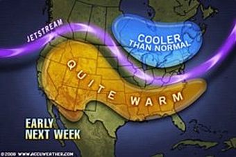
(STATE COLLEGE, Pa.) - AccuWeather.com reports a broad flow of warm dry air from western Canada to the Southeast will prevent the development of severe weather over the next few days while derailing the severe storms that have tracked out of the Southwest. Meanwhile, the high pressure producing record-breaking heat in the West will move through the Rockies this weekend bringing a significant pattern change east of the Continental Divide.
Record Rain Mid-Atlantic
Today, the storm that tore across Texas and the Southeast on Wednesday and Thursday has moved to the mid-Atlantic. Steady rain will fall from the Ohio Valley to the Delmarva, while stronger storms could erupt along the Southeast coast.
The heaviest rain has already left the waterlogged Baltimore - Washington corridor. The rain that fell through 6:00 AM EDT in Washington D.C., increased the total rain since May 1st to 8.53 inches. With the month only half over, this is now the fourth wettest May on record in the nation's capital.
According to Expert Senior Meteorologist Bernie Rayno, "Saturday will be much, much nicer along the Interstate 95 corridor, although parts of New England may not dry out until the afternoon." Rayno adds, "From Hartford and New York City to the south it will be a beautiful day, but it won't be as nice further inland."
Summer-Level Heat Hits West Early
Heat in the West will peak today with temperatures in Oregon and the rest of the Pacific Northwest above summer levels. The forecast high of 88 degrees in Seattle, Washington, is 4 degrees above the daily record set in 1985 and 11 degrees above the normal high temperature for early August.
The offshore winds pumping the hot desert air into the Los Angeles Basin and the California coast could cause problems for drivers of high profile vehicles in the canyons and passes, while elevating the fire danger in Southern California.
Check the video below for the latest NW weather update.
Source: AccuWeather.com
Articles for May 15, 2008 | Articles for May 16, 2008 | Articles for May 17, 2008
Salem-News.com:

Quick Links
DINING
Willamette UniversityGoudy Commons Cafe
Dine on the Queen
Willamette Queen Sternwheeler
MUST SEE SALEM
Oregon Capitol ToursCapitol History Gateway
Willamette River Ride
Willamette Queen Sternwheeler
Historic Home Tours:
Deepwood Museum
The Bush House
Gaiety Hollow Garden
AUCTIONS - APPRAISALS
Auction Masters & AppraisalsCONSTRUCTION SERVICES
Roofing and ContractingSheridan, Ore.
ONLINE SHOPPING
Special Occasion DressesAdvertise with Salem-News
Contact:AdSales@Salem-News.com


Terms of Service | Privacy Policy
All comments and messages are approved by people and self promotional links or unacceptable comments are denied.
[Return to Top]
©2026 Salem-News.com. All opinions expressed in this article are those of the author and do not necessarily reflect those of Salem-News.com.