
Publisher:
Bonnie King
CONTACT:
Newsroom@Salem-news.com
Advertising:
Adsales@Salem-news.com

~Truth~
~Justice~
~Peace~
TJP
Nov-30-2007 18:59

 TweetFollow @OregonNews
Skiers Beware! Avalanche Watch in Northern Oregon Cascades
Salem-News.comBack country travelers should be very aware of the significantly increasing Avalanche Danger over the weekend and into early next week.
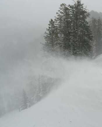 Photo: avalanche.org |
(SALEM, Ore.) - An Avalanche Watch has been issued by the National Weather Service for the Olympics, Washington Cascades and the Mt. Hood area for Sunday and Monday.
With an already unstable snowpack in place, abundant new snowfall mid-to-late Saturday and Sunday is expected to combine with increasingly strong winds and a warming trend mid-to-late Sunday into Monday, to produce a substantial increase in Avalanche Danger both Sunday and Monday.
According to the NWAC (Northwest Weather and Avalanche Center), the relatively shallow snowpack in some areas is helping to limit the Avalanche Danger at this time, but significant new snowfall that is anticipated mid-late Saturday and Sunday will cover much of the current terrain and vegetative anchors.
Large amounts of increasingly dense wind slab should load and stress a variety of buried weak layers on Sunday.
Consequently, both natural and human triggered slides will become increasingly likely in steeper avalanche terrain, especially on Lee Slopes above 4 To 5000 Feet where a deeper snowcover exists.
Initially, most slides that release should primarily involve only the most recently deposited new snow received late Saturday and early Sunday. However, with more significant warming and sustained heavy loading likely later Sunday, larger slab slides ranging from 3 to 5 Feet or more should become probable as the increased stresses affect more deeply buried weak layers.
As a result, back country travelers should remain very aware of the significantly increasing Avalanche Danger over the weekend and into early next week and modify their route selections and trip plans accordingly.
Please consult the www.nwac.us web site for further and more detailed information. Stay with Salem-News.com for updated information, updated as conditions warrant.
Backcountry travelers should be aware that elevation and geographic distinctions are approximate and that a transition zone between Dangers exists.
Remember there are avalanche safe areas in the mountains during all levels of avalanche danger.
Contact local authorities in your area of interest for further information.
NWAC Weather Data and Forecasts are also available by calling:
206-526-6677 For Washington
503-808-2400 For The Mt Hood Area
Or Visit:www.nwac.us.
Articles for November 29, 2007 | Articles for November 30, 2007 | Articles for December 1, 2007


Quick Links
DINING
Willamette UniversityGoudy Commons Cafe
Dine on the Queen
Willamette Queen Sternwheeler
MUST SEE SALEM
Oregon Capitol ToursCapitol History Gateway
Willamette River Ride
Willamette Queen Sternwheeler
Historic Home Tours:
Deepwood Museum
The Bush House
Gaiety Hollow Garden
AUCTIONS - APPRAISALS
Auction Masters & AppraisalsCONSTRUCTION SERVICES
Roofing and ContractingSheridan, Ore.
ONLINE SHOPPING
Special Occasion DressesAdvertise with Salem-News
Contact:AdSales@Salem-News.com

Terms of Service | Privacy Policy
All comments and messages are approved by people and self promotional links or unacceptable comments are denied.
[Return to Top]
©2026 Salem-News.com. All opinions expressed in this article are those of the author and do not necessarily reflect those of Salem-News.com.