
Publisher:
Bonnie King
CONTACT:
Newsroom@Salem-news.com
Advertising:
Adsales@Salem-news.com

~Truth~
~Justice~
~Peace~
TJP
Jun-09-2014 19:43


 TweetFollow @OregonNews
Progress Made on Two Bulls Wildfire; Evacuations, Road Closures Still in Place
Kevin Hays Salem-News.comThe Two Bulls Fire has still not reached the City of Bend's Bridge Creek watershed nor is it jeopardizing the city's "Outback" drinking water facilities.
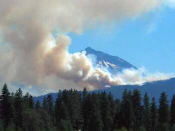 Good progress was made today on the east flank of the Two Bulls fire west of Bend. Photo: Kevin Hays Salem-News.com |
(BEND, Ore. ) - Good progress was made today on the east flank of the Two Bulls fire west of Bend.
Fire crews have most of that side complete with hose lines and lots of mop up continues with the advancement of the hose lays. Line construction on the west flank of the fire continues and is progressing well. Helicopters assigned to the fire are supporting that line construction operation.
A considerable amount of smoke was visible from the fire with the increased winds that developed in the afternoon with the arrival of an upper level weather disturbance over the fire.
Structure protection task forces mobilized under the Conflagration Act continue their work around the structures and mitigation plans are in place should the fire jump containment lines.
6,800 acres consisting of heavy brush and timber
50 homes remain under Level III Evacuation
No structures lost or damaged
1 Firefighter with a minor leg laceration
Cause under investigation
25% containment
11 helicopters, 48 engines, 11 dozers, and over 800 personnel assigned to the fire
Estimated costs to date- $2.2 million
Evacuation Information:
After meeting with Two Bulls Fire Officials, the Sheriff's Office is leaving Evacuation Notice Levels the same for Monday night and Tuesday.
The Level III Evacuation Notice for Skyliners Road residents outside the City of Bend is the only Level III notice still in effect.
A Level II Evacuation Notice is in effect for the Saddleback Subdivision area to include some evacuated homes on Johnson Road, Tyler Road and Kuhlman Road. THIS AREA IS OPEN TO RESIDENTS ONLY. Proof of residency is required at the Sheriff's Office Road Blocks. Sheriff's Office deputies continue to patrol these areas.
Note: We highly recommend residents continue to avoid this area, however if they choose to return we recommend they leave their livestock where it is boarded. If residents choose to return, we encourage them to be very cautious as there will be firefighting equipment working in the area. If fire conditions change, residents should be prepared to leave immediately.
A Level II Evacuation Notice is in effect for residents in the area located south of Shevlin Park Road, west of Mt. Washington Drive, and north of Century Drive.
A Level I Evacuation Notice is in effect for residents in the remainder of Northwest Crossing (east of Mt. Washington Drive), and the area that includes residents north of Shevlin Park and west of Mt. Washington Drive.
Current Sheriff's Office Roadblocks:
Tumalo Reservoir Road at Rock Springs Road
Bull Springs Road west of Johnson Road
4606 Road at the 460 Spur Road
Skyliners Road at Phil's Trailhead
The Bend Police Department, in cooperation with the Deschutes County Sheriff's Office, has developed a comprehensive evacuation plan for neighborhoods on the west side of Bend that will be implemented if necessary.
Deschutes County I. T. has produced a link to a map that shows the current Evacuation Notice Levels, Interactive Map: https://maps.deschutes.org/custom/simple/index.html
Evacuation Levels Explained:
Level I (Ready)
Residents should be aware of the danger that exists in their area, and monitor local media outlets for information. Residents with special needs, such as those susceptible to breathing problems in wildfires or those with animals and pets, should take note and begin making arrangements to evacuate. For wildfires, smoke can often cause the most problems for residents, especially those sensitive to smoke. Evacuations at this time are voluntary.
Level II (Set)
This level indicates there is significant danger to your area, and residents should either voluntarily relocate to a shelter or with family/friends outside of the affected area. For those that choose to remain, they should be ready to leave at a moment's notice. Access into the area is typically controlled by law enforcement. Law enforcement may also decide to not allow residents back into the area once they leave.
Level III (Go)
This level means to leave immediately! Danger to your area is current or imminent, and your life safety cannot be guaranteed. Residents should listen to local media, and watch for emergency personnel who may be coming by to give further instructions regarding the evacuation.
School Closures:
At 5:30 p.m. Monday night, the Two Bulls Fire incident commander confirmed with Bend-La Pine Schools that the established Level Two evacuation orders - west of Mt. Washington Drive and north of Century Drive - will continue through the night, due to the fire burning in the area.
As a result of these orders, William E. Miller Elementary, Cascade Middle and Summit High schools will remain closed on Tuesday, June 10 as the schools are situated within the Level Two evacuation area.
All other schools will be open as scheduled, including High Desert Middle School. High Desert Middle School is the designated Red Cross shelter site, though at last report there are no residents currently using the shelter. The school will operate in partnership with the shelter tomorrow and into the week, if necessary.
Finals will be rescheduled; students can visit their school's website for more information.
Schools in Bend, La Pine and Sunriver may have indoor recess this week, as smoke is expected to move back into the area tonight. We will be monitoring outdoor air quality regularly in the days to come and will be consulting with the Air Quality Specialist from the US Forest Service.
Watershed Information:
The Two Bulls Fire has still not reached the City of Bend's Bridge Creek watershed nor is it jeopardizing the City's "Outback" drinking water facilities.
The Bridge Creek watershed is where the City gets most of its domestic water supply, fed by gravity to the City. The City shut down the surface water on Saturday night as a protective measure, and has been pumping water only from groundwater wells since.
The Outback facility is where the City treats and distributes water from Bridge Creek. It's also home to seven of the City's 22 groundwater wells. Outback is about 9 miles east of the watershed. The fire is about 1.5 miles north of the Outback site.
The City shuts off its surface water when turbidity - a measurement of sediment-generated cloudiness - reaches a certain level. The turbidity measurement is currently below that threshold.
The City hopes to have the Bridge Creek surface water source back on in a few days. The City can turn that source back on if water quality allows. Water quality can be affected by fire behavior and spring run-off. Today, despite the fire, the turbidity (a measurement of cloudiness) was below the threshold for shutting down Bridge Creek source.
Groundwater wells can supply the City's domestic water needs, but the City is encouraging its Bend water customers to conserve water and minimize irrigation. If it's necessary to irrigate, it is best to do so during off-peak hours (when it is dark outside).
Red Cross Information:
As of 5:30 p.m., the Red Cross shelter at High Desert Middle School has closed. Those in need of immediate assistance should call 888-680-1455. The Red Cross is working in collaboration with local and state agencies to remain ready to reopen the shelter should additional evacuations occur, and volunteers will be on standby to respond if the shelter reopens.
Red Cross volunteers will be conducting outreach in and around the Bend area tomorrow, providing wildfire preparedness information and assistance in downloading the Red Cross Wildfire App. The Red Cross asks that people not bring in-kind donations of to the evacuation center and encourage them to donate financially to the Red Cross so needed supplies can be purchased.
Area Closure Order:
THE TEMPORARY AREA AND USE RESTRICTIONS FOREST SERVICE SYSTEM ROADS AND TRAILS FOR DESCHUTES NATIONAL FOREST REMAIN IN PLACE.
Closed Forest Service System Roads:
Forest Road 370 North of Todd Lake
Forest Road 1628
Forest Roads 590, 605, 480, 113, 110, 377, 900, 1620
Forest Road 1612
Forest Road 4606
Forest Road 4601 W. of Tumalo Creek.
Air Quality Information:
As of 4:00 p.m. Monday smoke conditions are GOOD at monitors located in Bend and Sisters. Additional smoke monitoring equipment has been ordered to increase data collection in the area of Summit High School and Redmond Air Center.
Drivers may experience smoke impacts on nearby roads. If smoke drifts onto roads, motorists should slow down, turn on headlights, and proceed with care. Due to the Two Bulls wildfire, smoky conditions are expected to persist throughout Deschutes County for an indefinite amount of time. Deschutes County Health Services will continue to communicate to the public the health impact of wildfire smoke inhalation on an ongoing basis until the fires reside.
WHO IS AT HIGHER RISK FROM WILDFIRE SMOKE?
People with chronic lung or heart conditions, the elderly, children, and pregnant women have a higher risk of health problems from breathing dense wildfire smoke. People in these risk groups should minimize the impacts of wildfire smoke when it appears or smells the strongest or when DEQ indicates "unhealthy" air conditions by:
1. Staying indoors
2. Avoiding outdoor activities until air quality improves Closing windows and doors, and
3. Using air conditioners and filters.
Those suffering from asthma or other respiratory conditions should follow their breathing management plans; keep medications on hand, and contact healthcare providers if necessary. Remember-the longer poor smoke conditions linger, the more likely a person's health may be affected. Please be prepared and think ahead regarding ordering medications.
Animals Care:
The livestock shelter is still open at the Deschutes County Fairgrounds in Redmond, Oregon.
Information in this story provided by the Oregon Department of Forestry and the Deschutes County Sheriff's Office
Salem-News.com will have more on this story as soon as it becomes available
 |
Articles for June 8, 2014 | Articles for June 9, 2014 | Articles for June 10, 2014

googlec507860f6901db00.html
Salem-News.com:


Terms of Service | Privacy Policy
All comments and messages are approved by people and self promotional links or unacceptable comments are denied.
[Return to Top]
©2026 Salem-News.com. All opinions expressed in this article are those of the author and do not necessarily reflect those of Salem-News.com.